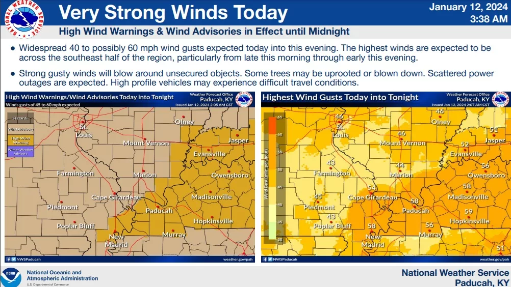
A High Wind Warning is in effect for all of western Kentucky all day Friday.
According to the National Weather in Paducah, there is a chance of wind gusts reaching speeds of 60 MPH throughout the day. Additionally, there is a possibility of a few thunderstorms occurring before early afternoon, some of which may be severe. The primary concerns with these severe thunderstorms would be the potential for winds exceeding 60 MPH and the presence of large hail. Furthermore, the storms on Friday could result in rainfall ranging from 1.5 to 3 inches, with the potential for even higher amounts in some areas.
Following the current system, the focus shifts to an impending arctic cold that is expected to sweep through the region over the weekend. The coldest temperatures are anticipated to arrive from Sunday onwards until Tuesday night. The severity of the cold spell will be influenced by the amount of snowfall that occurs during a potential winter storm on Sunday and Monday.
According to NWS officials, artic cold air is anticipated with wind chills below zero likely, and the possibility of dropping as low as 20 degrees below zero or even colder. The duration of this cold weather is causing significant concern, as it could result in one of the longest stretches of sub-freezing temperatures witnessed in the region in the last three decades. Additionally, there is a chance of accumulating snow on Sunday night and Monday, although the exact amounts and areas affected by the snowfall are still uncertain.
Cold weather tips have been added to our websites and can be found here. If you have any closings or delays to share with us, email them to info@wektradio.com.